Rivers of People: Mapping Sudan's Mass Displacement
When conflict erupted across Sudan in April 2024, satellite imagery began recording something unprecedented: the emptying of entire neighborhoods in Khartoum, the formation of massive human corridors moving toward borders, and the spontaneous creation of new settlements across three countries. Over 9 million people—nearly one in four Sudanese—were forced from their homes in what became the world's largest displacement crisis.
This is not simply a story of individual refugee families, though their courage anchors every frame. This is the documentation of geographic transformation—the moment when human movement reaches such scale that it reshapes borders, creates new economies, and forces the redrawing of regional maps. From above, the displacement looks like rivers: dark streams of people flowing across desert landscapes toward uncertain refuge.
As a GIS specialist turned photographer, I have spent years mapping population movements through data points and satellite analysis. But numbers cannot capture what I witnessed in 2024: the grandmother carrying her granddaughter across 200 kilometers of desert, the father using his phone's GPS to navigate routes that previous generations never imagined, the children born during the crossing who will know no other home than the journey itself.
This series documents displacement as both human tragedy and geographic phenomenon. It follows the major migration routes—from Khartoum's evacuation through the crushing bottlenecks at Chad's border, from the Nile corridor toward Egypt to the dangerous crossings into South Sudan. Each route tells different stories of survival, but together they reveal how mass displacement operates at scales that challenge our understanding of borders, citizenship, and belonging.
The aerial documentation shows what ground-level coverage cannot: the sheer magnitude of human movement that affects entire regions. From 500 meters above, you can see the organized chaos of 50,000 people queued at a single border crossing, the spontaneous road networks created by millions of footsteps, the geometric precision of new refugee settlements that will likely become permanent cities.
But this series also insists on the individual within the mass. Every aerial shot is paired with intimate ground-level documentation that honors the specific families whose decisions and courage create these vast patterns of movement. The elderly woman navigating displacement using skills learned during previous wars. The young mother calculating water supplies for a journey she hoped never to make. The teenage boy who becomes family translator because he learned English on his phone.
Sudan's displacement crisis represents more than humanitarian emergency—it documents the contemporary reality that millions of people worldwide live in perpetual movement, creating new forms of community and belonging that transcend the nation-state system designed to contain them. These rivers of people are carving new geographies that will reshape the region for generations.
Photographer Bio
Zara Al-Bashir combines technical expertise in geographic information systems with documentary photography to create unprecedented documentation of population movement and displacement. Originally trained as a GIS specialist, she spent five years with UN agencies mapping population displacement across the Horn of Africa before transitioning to photography.
Her background in satellite analysis and demographic mapping provides unique perspective on mass displacement that allows her to document both individual human stories and systemic patterns of movement. Al-Bashir's previous series on South Sudan displacement won international recognition for combining scientific precision with emotional depth.
Based in Cairo since 2019, Al-Bashir maintains access to Sudan while working safely across the region. Her photography has been featured in major exhibitions on migration and displacement, with her work influencing humanitarian response planning through its integration of technical analysis with human storytelling. She advocates for recognition of displacement as geographic transformation requiring regional rather than national responses.
Image Captions
#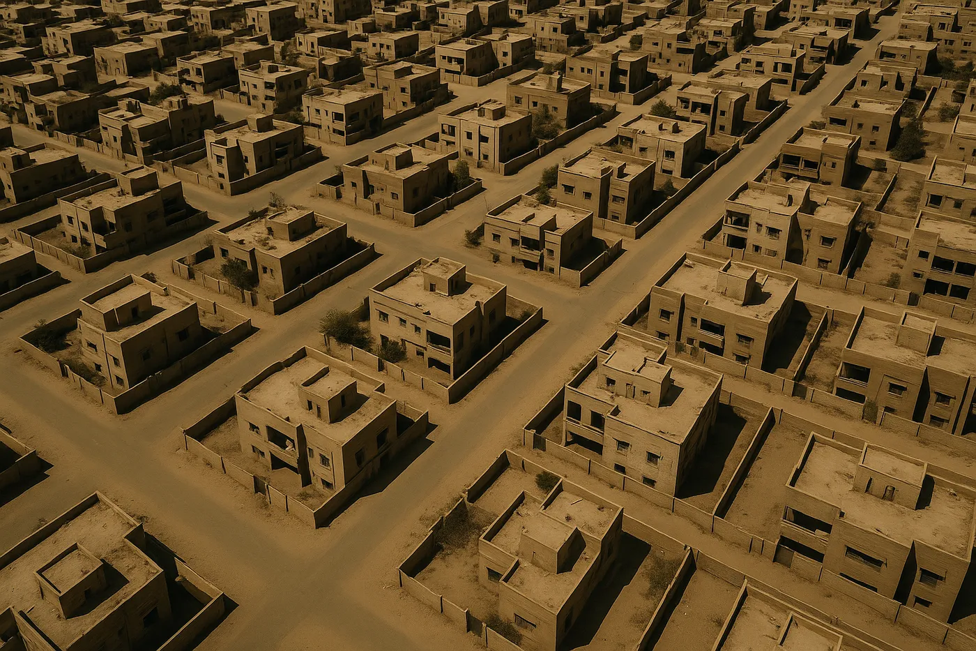
Image 1: The Emptying of Khartoum
Aerial view of abandoned residential neighborhood in Khartoum showing the scale of urban evacuation
Satellite imagery from April 2024 captured something unprecedented: entire neighborhoods of Sudan's capital emptying within days as conflict made the city uninhabitable. This aerial view of the Riyadh district shows abandoned homes, empty streets, and the ghostly infrastructure of a city suddenly drained of its people. What had been home to 100,000 residents became a geography of absence, with only occasional movement visible as remaining families gathered belongings for journeys they never imagined making. The geometric order of planned neighborhoods contrasts sharply with the chaos that forced their abandonment.
#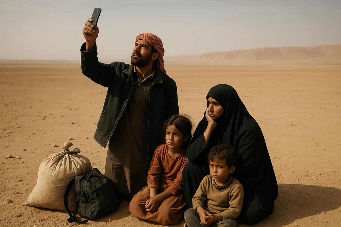
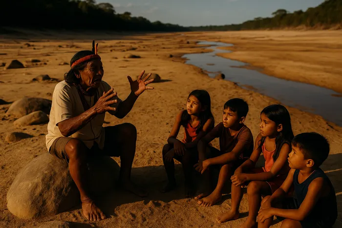
Image 2: Desert Navigation
Family using phone GPS to navigate displacement route across desert landscape toward Chad border
Ahmed holds his phone toward the sky, searching for GPS signal as his family rests during their 200-kilometer journey toward Chad. Modern technology aids ancient survival migration as displaced families use smartphone navigation to cross landscapes that have swallowed previous generations of travelers. His wife Fatima checks their water supplies while their three children sleep in the shade of their single bag. The phone screen shows their location as a small blue dot moving across vast emptiness—technology revealing both their progress and their vulnerability within the immense geography of displacement.
#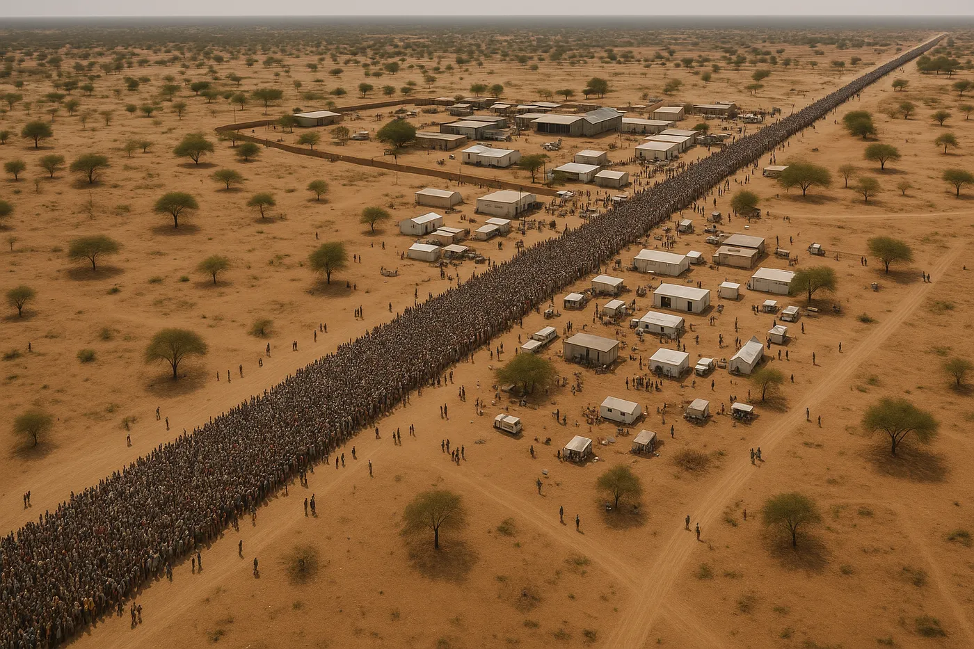
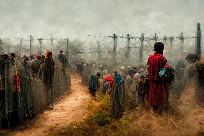
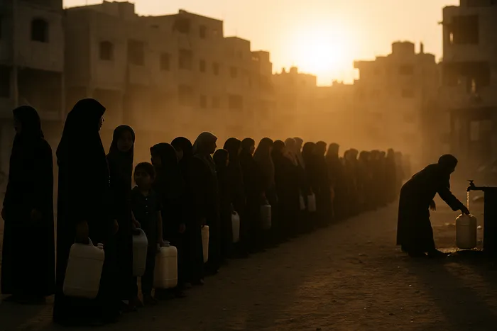
Image 3: Border Bottleneck
Thousands of people queued at Chad-Sudan border crossing showing mass displacement at international boundaries
The Adré border crossing was designed for routine trade and family visits, not for processing 2,000 displaced families daily. From above, the human queue extends 3 kilometers into Sudan, a dark river of people carrying everything they could save from their previous lives. Chadian officials process documents while humanitarian organizations distribute water and medical care, but the scale overwhelms all systems designed for normal border crossing. The international boundary becomes a humanitarian chokepoint where family survival depends on paperwork and processing capacity never designed for mass displacement.
#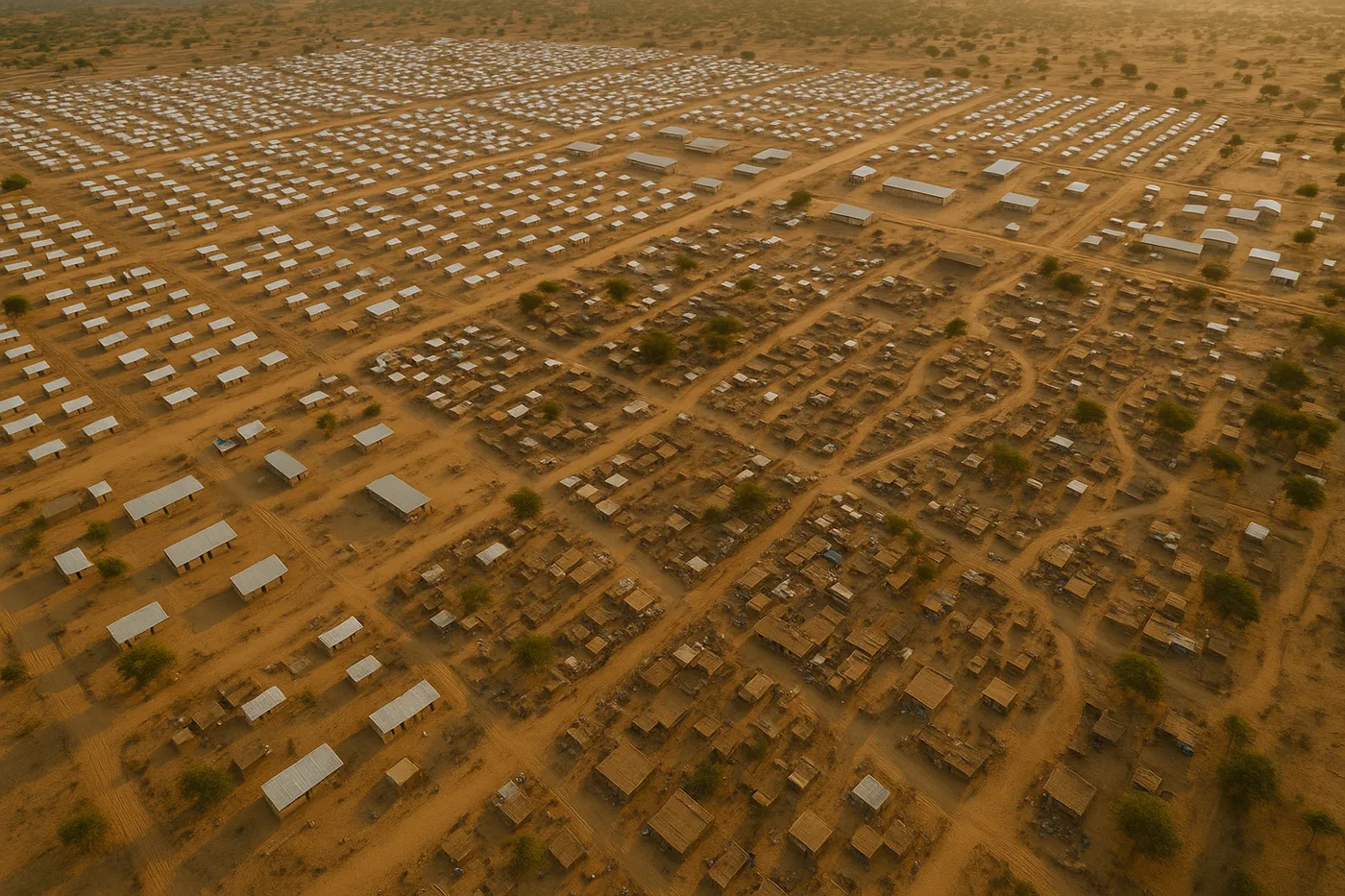
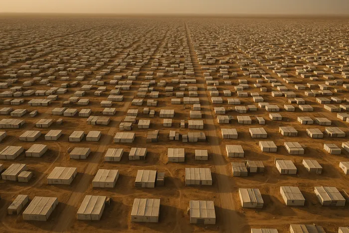
Image 4: Spontaneous Settlement
New refugee settlement in Chad showing rapid community formation across international borders
What began as emergency shelter has evolved into Chad's newest city within six months. Aerial documentation reveals how displaced families create neighborhood organization, market centers, and community infrastructure that mirrors the urban environments they left behind. The geometric order imposed by humanitarian agencies gives way to organic community development as residents establish social networks, economic relationships, and cultural institutions. The settlement houses 45,000 people—larger than most Chadian towns—yet remains officially temporary despite clear evidence of permanent community formation.
#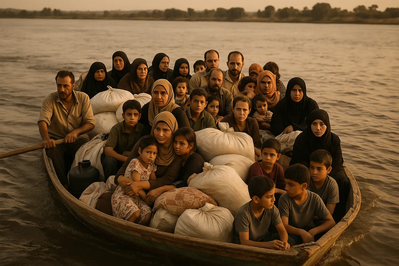
Image 5: The Nile Route
Families loading onto overcrowded boat for journey north along the Nile toward Egypt
The ancient Nile route becomes modern displacement corridor as families choose river travel over dangerous desert crossing. Overcrowded boats carry displaced families north toward Egypt, following the same river that has served travelers for millennia. The wooden boat carries thirty people designed for ten, with belongings and children packed between adults who take turns steering toward uncertain refuge. The river journey takes three days through landscapes marked by previous displacement waves, with families sharing water, food, and stories of the homes they left behind.
#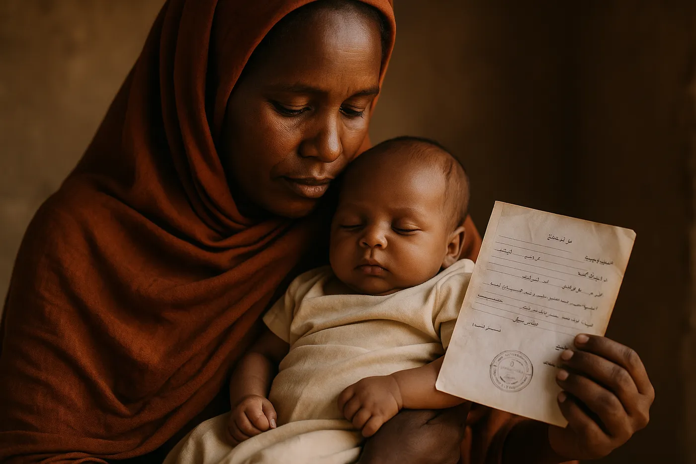
Image 6: Child of the Crossing
Portrait of child born during family's displacement journey, representing the new generation shaped by movement
Amina was born during her family's journey to Chad, delivered by a nurse from another displaced family while camped at a water point used by thousands of crossing families. Now six months old, she has known no home except movement—carried across borders, fed by women from different tribes, protected by communities formed through shared displacement. Her mother Khadija holds documents marking Amina as born "in transit," a designation that captures the contemporary reality of children whose citizenship and belonging are defined by movement rather than place.
#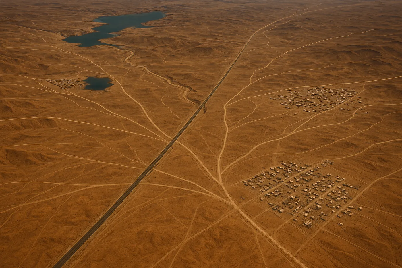
Image 7: New Geography
Wide landscape shot showing how displacement creates new road networks and settlement patterns
Displacement creates new geography visible from aerial perspective: the worn pathways connecting water sources, the spontaneous markets emerging at crossroads, the communications networks linking scattered communities. What appears as empty desert to untrained eyes reveals itself as complex infrastructure created by human movement. The new road networks, carved by millions of footsteps, will likely become permanent trade routes connecting communities across borders. Emergency settlements show signs of permanence through expanding infrastructure and deepening social organization that suggests these new geographies will reshape the region for generations.
Photo Prompts
#
Image 1: The Emptying of Khartoum
Aerial drone photograph of abandoned residential neighborhood in Khartoum Sudan showing urban evacuation, empty streets and abandoned homes in geometric residential layout, shot on DJI Mavic 3 from 300 meters altitude, harsh midday lighting creating stark shadows between buildings, wide angle lens capturing neighborhood scale, muted desert colors with abandoned infrastructure, documentary color grading emphasizing absence and emptiness, award-winning photojournalism, World Press Photo style aerial documentation
#
Image 2: Desert Navigation
Sudanese family in desert landscape using smartphone GPS for navigation during displacement journey, father holding phone toward sky searching for signal while family rests with minimal belongings, vast desert landscape extending to horizon, shot on Canon EOS 5D Mark IV with 35mm f/2.8 lens, natural daylight emphasizing isolation and technology contrast, composition showing human scale within vast geography, warm desert color palette, documentary style emphasizing survival and modern technology in displacement, World Press Photo winning photojournalism
#
Image 3: Border Bottleneck
Aerial view of thousands of people queued at Chad-Sudan border crossing Adré, massive human queue extending kilometers into Sudan, border infrastructure overwhelmed by displacement scale, humanitarian organizations providing assistance, shot on DJI Mavic 3 from 400 meters altitude, natural lighting showing queue organization and human scale, wide composition capturing border bottleneck and processing challenges, documentary color grading emphasizing mass movement and infrastructure limits, award-winning photojournalism, World Press Photo documentary style
#
Image 4: Spontaneous Settlement
Aerial documentation of new refugee settlement in Chad showing rapid community organization, geometric humanitarian layout evolving into organic neighborhood development, market centers and community infrastructure visible, shot on DJI Mavic 3 from 250 meters altitude, golden hour lighting revealing settlement expansion and organization, wide angle capturing settlement scale and community formation, earthy color palette emphasizing permanent settlement characteristics, World Press Photo style documentary photography
#
Image 5: The Nile Route
Overcrowded wooden boat carrying displaced Sudanese families along Nile River toward Egypt, thirty people packed with belongings on boat designed for ten, families sharing space and resources during river journey, shot on Canon EOS 5D Mark IV with 50mm f/4 lens, natural river lighting emphasizing overcrowding and journey conditions, medium composition showing human density and river travel, warm color processing highlighting family solidarity during difficult journey, award-winning photojournalism, World Press Photo documentary style
#
Image 6: Child of the Crossing
Portrait of mother holding infant born during displacement journey, baby born in transit between Sudan and Chad, mother showing documents marking child as born during crossing, shot on Canon EOS 5D Mark IV with 85mm f/1.8 lens, soft natural lighting emphasizing maternal protection and child innocence, intimate portrait composition highlighting mother-child bond within displacement, warm color processing emphasizing human dignity and new generation born in movement, World Press Photo winning portrait photography
#
Image 7: New Geography
Wide landscape aerial shot showing displacement-created infrastructure across desert terrain, new pathways connecting water sources and settlements, spontaneous road networks carved by human movement, shot on DJI Mavic 3 from 500 meters altitude, natural lighting revealing human-created geography and settlement patterns, ultra-wide composition capturing regional transformation and new infrastructure, documentary color grading emphasizing geographic change and human impact on landscape, award-winning photojournalism, World Press Photo style geographic documentation
Photographer Portrait Prompt
Professional portrait of Sudanese-Egyptian woman photographer in her early thirties, shoulder-length curly dark hair, intelligent eyes with determined expression, wearing practical field clothing, GIS mapping equipment and professional camera visible in background, shot in natural light with technical equipment context, professional documentary photographer aesthetic, emphasizing both technical expertise and fieldwork experience, professional portrait photography